The Christkind's - Mapping the Route

Story
With packaging and storage optimized, the Christkind turned its focus to the most critical step: delivery. Ensuring joyful surprises in countless households across Austria and parts of Germany was no small task. Efficiency, time management, and precision were key.
This year, the Christkind realized that route planning, typically a time-consuming process, needed a serious upgrade. While some homes allowed decorations as early as the night of December 23rd—because their living rooms were already locked—others required everything to be prepared within just a few hours on Christmas Eve.
Time and location are vital. For smaller children, the Christkind often arrives at 3 PM, while families with older children can wait until 6 PM. But the most magical moment of all is ringing the bell at precisely the right time—signaling that Christmas has arrived.
To streamline this, the Christkind imagined a modern, digital sleigh powered by a Model-Driven Power App. This app was designed to handle route optimization with ease, enabling helpers to:
Plan routes efficiently based on specific time windows and geographic locations. Prioritize deliveries to ensure timely arrivals. Simplify logistics, reducing the stress of last-minute planning. The Christkind also wanted to make the app easy and enjoyable for helpers to use. By integrating a Map, it became possible to optimize delivery sequences visually, taking into account travel distances and the time needed at each stop.
With this new tool, the Christkind organized a small-scale trial to test the system. The results? Faster and more efficient deliveries, with helpers arriving on time at every household. The Christkind beamed with joy, knowing that this new solution brought precision to its magical mission.
With Austria and parts of Germany glowing with festive cheer, the Christkind’s digital sleigh proved to be a game-changer, ensuring that every bell rang at the perfect moment, creating unforgettable memories for all.
Implementation
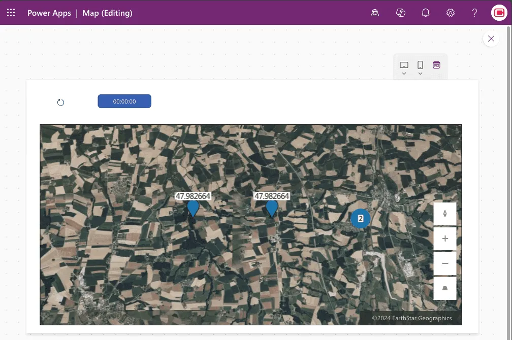
To incorporate location-based features into the app, I added the fields Longitude and Latitude to the Household table. These fields were populated using Excel Copilot, which made generating the GPS coordinates a breeze.
For displaying the locations, I used the PowerApps Interactive Map Control as a starting point. This control allows easy visualization of pins for households based on their coordinates.
Key Considerations:
- The map control supports up to 5,000 pins for coordinates (latitude/longitude) and 50 pins for address-based locations.
- While the example works well for smaller datasets, scaling this for real-world data would require a custom implementation to handle larger volumes effectively.
For this sample, the map control worked seamlessly with the generated coordinates. However, in a production scenario, a tailored solution would be developed to ensure optimal performance and user experience. The generated coordinates provided by Excel Copilot proved to be an excellent foundation for testing and demonstrating this feature.
Remark
PowerApps Interactive Map Control for visualization makes adding geospatial features to your app quick and straightforward. Just remember the map control’s pin limitations when scaling to larger datasets!
Links
- 1: The Challenge of the Letters
- 2: The Christkind’s Data Transformation - Transforming Letters into Forms
- 3: The Christkind’s Magical Email Solution
- 4: The Christkind’s Magical PWA - Transforming Children’s Letters into Digital Art
- 5: The Christkind’s Ingenious Snail Mail Solution - Bringing Letters to Life
- 6: The Christkind’s Ingenious Snail Mail Solution - Embracing the Flow
- 7: The Christkind’s Ingenious Snail Mail Solution - To the next level
- 8: The Christkind’s - Deployment Dilemma
- 9: The Christkind’s - Spreading the Christmas Spirit
- 10: The Christkind’s - Upgrading the Production Line PowerApps
- 11: The Christkind’s - Upgrading the Production Line Excel
- 12: The Christkind’s - The Christkind’s - Documenting the Christkind’s Journey
- 13 - The Christkind’s - The preparation for the call with Santa
- 14 - The Christkind’s - The Meeting with Santa
- 15 - The Christkind’s - Enhancing Knowledge Access with Graph Connectors
- 16 - The Christkind’s - Fine-Tuning the Graph Connector for Better Copilot Answers
- 17 - The Christkind’s - Building a Custom Agent with Copilot Studio
- 18 - The Christkind’s Building a Custom Bot with VSCode
- 19 - The Christkind’s - The Christkind’s - A Surprising Discovery Copilot and the Bot
- 20 - The Christkind’s - The Christkind’s - Discovering the Magic of Github Copilot
- 21 - The Christkind’s - Optimization of Delivery with a Custom Control
- 22 - The Christkind’s - Optimization of the Supply Chain